
Dronestar™ Agriculture
Welcome to Dronestar™ Agriculture.
Excellence in Ag training.
Dronestar™ Ag, design and deliver training courses on the latest Agricultural survey, mapping, spray and seeding aircraft systems from DJI. With us, you leave with all you need from your initial training through to targeted courses to meet your exact, on-farm needs, using the very latest in aerial application systems.
Glad you found us. You're in the right place.
Dronestar™ Agriculture.
Here at Dronestar™, we do things a little differently to other organisations. We not only offer full hardware supply along with a comprehensive suite of training courses, for new and existing pilots wanting to achieve their RePL, we go a long way past that. Agricultural operations have advanced so rapidly, we feel it's critically important to not just offer basic training to get you to 'the required knowledge level' to pass a Remote Pilot's Licence, but to be able to give you exactly what you need when making significant capital investment in Ag aircraft.
Ag Drone Capability.
We specialise in the DJI AGRAS T-Series and mapping aircraft, their systems, applications and software platforms, to expertly deliver courses that directly benefit you. We don't just sell you an aircraft and basic training to get your licence and type rating. The DJI Ag ecosystem is complex. There's a lot you need to know - and a lot you don't. Our Agribusiness customers come to us from all parts of the country, and from all sorts of use scenarios; from wide open flat land, through extremely steep and challenging environments with multiple obstacles, radio dead spots, power lines, areas that need specific application and non-application rates. Areas that need to be closely monitored over time, using light invisible to the naked eye, are some of the many examples and use scenarios our courses cover.
Our Ag Training.
We have split Ag training up into logical components (units of competency) that allow us to tailor a complete solution - contextualised to you, and practically delivered to you, often at your premises, guiding you through the training, in your real-world scenario. All training starts at the beginning with your Remote Pilot's Licence. Once that's complete, we move to your chosen aircraft (we can supply directly). To fly Ag aircraft above 25KG (which they all are) , you need to have a Remote Pilot's Licence, and be individually 'type-rated' on your chosen aircraft. From there, we will train you specifically in your particular application areas. Whether that be to run surveys, map in 2D and 3D, use Multispectral Data to generate 'prescriptions' for chemical application across large or smaller areas and apply variable rate weed. pest control or fertiliser.
Delivery Locations.
Although we do schedule some of our Ag deliveries, given the wide and varied requirements of our clients, we generally deliver on-site at your property. This allows us to deliver any hardware you've purchased, at the same time as delivering your course(es), and allows us to help you learn in your real-world scenario. Talk to us anytime to book your Dronestar™ Ag course and / or order aircraft and associated hardware.
Ag Aerial Survey and Mapping with Multispectral
Before we fly at any field, we need to map it so we're using exact, local data to proceed with further operations - not outdated or low-resolution satellite imagery which can lead to incidents and accidents we do not want with expensive aircraft. Using the Mavic Enterprise Series aircraft and D-RTK, this course teaches you exactly how to use this aircraft to analyse an area, using visible and multispectral data, along with post analysis in DJI SmartFarm and/or Terra. This is a one day course, usually delivered at your property for groups of up to 3 pilots.
Outcomes. You will leave confidently knowing how to use aircraft to map in 2D and 3D and automated terrain-follow modes, collect data, analyse it and generate custom spray/ seed prescriptions for your DJI T-Series aircraft to execute. You'll understand how to interpret various sensor indices, including widely used NDVI, OSAVI and LCI, to assess and manage crop health pro-actively. You'll then know how to load these plans into the T-Series Aircraft for execution and carry out that plan.


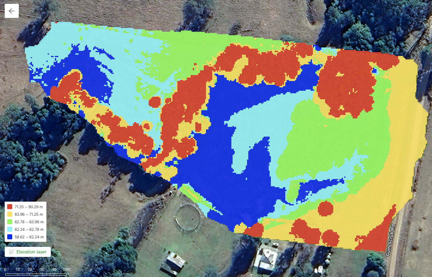
The images above were captured in one scan using the DJI Mavic Enterprise Multispectral, to create a variable rate application map for the AGRAS T series to execute. The top image shows NDVI multispectral data, the middle with overlayed spray-plan and the bottom, elevation data at the spray site.
Ag Aerial Survey and Mapping AGRAS T-Series
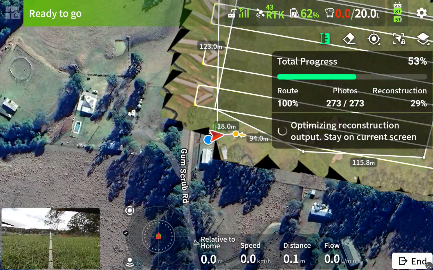
With any Ag delivery, we will always map our target area first to ensure we fly to the most accurate data available, To capture that, we need to run high-resolution scans of the area we want to work with. This ensures safety, and allows us to monitor progress of subsequent spray or seeding operations, with pin-point accuracy, repeatable over time. The DJI AGRAS T-Series along with 360 Degree vertical and horizontal RADAR, and D-RTK, allow for incredible survey and mapping operations with full terrain follow and obstacle avoidance in real-time.
The AGRAS T-Series, has a number of powerful mapping scenarios built in- as standard, to allow it to be the scout for any operation, in almost any terrain, with real time 2D and 3D construction on the DJI RC Plus as it flies, along with real-time sync to DJI SmartFarm for execution and sync with other tasks generated b the same aircraft, or other such as the Mavic 3 Multispectral, used in our course above.
Want to know more? Check out some of our articles around planning, mapping and spray plans :
Planning and Mapping using DJI Aircraft -
Click Here
Building custom spay plans in DJI Smartfarm -
Click Here
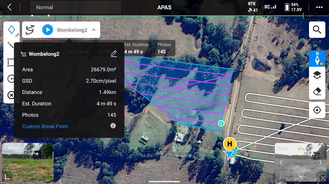

The above images were flown by an AGRAS T-25 in mapping mode to generate centimeter precise imagery to then combine with DJI SmartFarm multispectral data, captured by our Mavic 3 Multispectral to then spot, and variable rate spray this 4ha paddock.
Where to now?
In order to operate these aircraft either on your own property, non-commercially, or commercially on your own, or others, you will need your Remote Pilot's Licence (RePL) and a type rating on your chosen aircraft. We cover all of this at Dronestar™. From there you can choose to add on any of the specialised courses we offer such as those above. Generally, we will deliver your full course in a single week if that's your preference. The two packages below cover the requirement for those who want to fly non-commercially under the 'landholder rule', and those who want to operate as a commercial business. Your course can start as soon as you're enrolled, beginner with your Remote PIlot's Licence theory study. As always, call anytime at all - you'll talk to our expert Ag trainers with one simple call when it suits you.
Landholder (non-commercial) package
If you're wanting to fly for your own purposes, and not for hire or reward (i.e. you cannot take payment), and you have, or are buying your own aircraft, this is what you'll need. We usually deliver these courses as a full package, to you - we can also supply, deliver and set up your aircraft if you don't have one already. All licensing fees, charges and resources are supplied within this course.
Remote Pilots Licence (Multi-Rotor Class) $1350
Medium Category Training and CASA Type Rating $2250
Commercial package
For our commercial clients, there are a few additions that can be considered. We'll work those out with you when we speak. The following, however, are always required. We usually deliver these courses as a full package, to you - we can also supply, deliver and set up your aircraft if you don't have one already. All licensing fees, charges and resources are supplied within this course.
Remote Pilots Licence (Multi-Rotor Class) $1350
Medium Category Training and CASA Type Rating $2250
Remote Operator's Certificate (ReOC) with Ag $3750
Ag Training Enquiry
Dronestar™ Agriculture
Your comprehensive Agribusiness partner